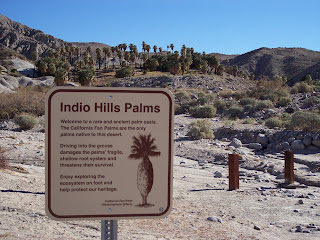
A friend of mine called and asked if I could take her husband, Harry, out hiking while they were in town. I had a few hours on Wednesday and said that I would be happy to. I only had to figure out where to go. As I was looking through some old pictures of a hike I did in the Indio Hills, I noticed what looked like a trail behind one of the palm oases that I'd never done. There are few things more exciting to me than a new trail so I figured I'd go out and give it a look.
To get to Biskra Palms is one of the many oases along the San Andreas Fault and it requires a Four Wheel Drive or at least a car with good clearance to get there. No problem for me but if you're thinking of going out there keep that in mind.
There is a trail to the East of the oasis but this is not the one I am going up today. Today's trail is West of the oasis.
Once on it, we discover that the trail is incredibly well made. There are sections where rocks were stacked to buttress the trail on the otherwise loose and rocky hillside.
Overall, the trail appears to be in good condition although these has been some erosion.
That is, until we get a little higher up. In this section, there has been MAJOR erosion and the going is very precarious. One mistake here and you'd slide a long way down a steep rocky slope. We are very careful going through this.
But we get past it and are rewarded with fantastic views of both Mount San Gorgonio and Mount San Jacinto.
We get a little higher on the trail and discover this little meadow-like basin. It's a very interesting little clear section that is completely free of rocks in these otherwise rocky hills.
The higher we get, the more we are rewarded with outstanding views of the Coachella Valley.
You are able to see the Salton Sea very well in the distance.
We continue upward and find sections of trail although for the most part the trail ended at the basin area.
There is another basin area just below the top. Mount San Gorgonio pokes through.
The top.
Since we didn't wear out lead underwear, we won't be going too close to the radio transmitters.
This benchmark is dated 1931 and instead of the usual USGS markings it is labeled Metropolitan Water District. I guess they put the first towers up when they were building the Colorado River Aqueduct.
We take a different, more direct ridge down and are rewarded with outstanding views the entire way.
At the last moment, we veer down this rocky side canyon as a shortcut.
There are some fascinating things in these hills and there's so much more to be discovered. I can't wait to come back.


No comments:
Post a Comment